


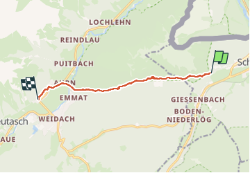
jour 1 Giessenbach- Gasse

baygonvert
User

Length
8 km

Max alt
1505 m

Uphill gradient
541 m
Km-Effort
14.8 km

Min alt
999 m

Downhill gradient
426 m
Boucle
No
Creation date :
2025-07-15 13:07:39.043
Updated on :
2025-07-15 15:17:18.058
2h09
Difficulty : Medium

FREE GPS app for hiking
 SityTrail
IGN / Geographical institutes
SityTrail Plus
The world is yours!
About
Trail Walking of 8 km to be discovered at Tyrol, Bezirk Innsbruck-Land, Gemeinde Scharnitz. This trail is proposed by baygonvert.
Photos

Positioning
Country:
Austria
Region :
Tyrol
Department/Province :
Bezirk Innsbruck-Land
Municipality :
Gemeinde Scharnitz
Location:
Unknown
Start:(Dec)
Start:(UTM)
669248 ; 5250544 (32T) N.
Comments